
Road trip highlights
Now that I’ve posted all of the photos from my drive West, I thought I’d point out some of the trip highlights. (Unfortunately, the photos are not in order and it would be too much work to get them rearranged. Oh well. UPDATE: I just realized it’s not necessarily that much work thanks to Flickr’s Organize feature. I’ve rearranged some of them, but with others, I just don’t quite remember anymore and the photo time stamps seem to be off.:()
For the geographically challenged (or those simply not familiar with this part of the United States), driving from Evanston, Illinois to Palo Alto, California requires crossing the following states: Illinois, Iowa, Nebraska, Wyoming, Utah, Nevada and California. Most of these states are incredibly long (that is, they have a wide east-west stretch), especially for someone who’s more used to the eastern part of the United States. Of course, you could also cross all sorts of other states while heading west (say, go north through Wisconsin, Minnesota, etc.), but I needed the quickest route, which is supplied by Interstate 80.
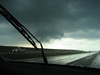 I’ve tried to pick a highlight for each state, but it’s not always obvious given that I didn’t have time to make detours with sightseeing purposes. In Iowa, the hail storm was the big event and I managed to capture a few photos, although they really don’t do it justice. It was much scarier and harder to navigate than it seems. I also neglected to take photos of the line of cars standing out on the shoulder of the highway waiting for the storm to pass. Of course, the twist in such a situation is that you likely get out of the storm quicker if you keep on driving, unfortunately, it’s practically impossible to drive when you’re in the middle of it. So that took a bit of time.
 An unrelated interesting aspect of Iowa was the free wifi that was advertised at every rest stop. I’m surprised that I’ve never heard Jeremy talk about this, it seems like the kind of thing he’d be proud of about his home state. I didn’t have time to try out the free wifi, but it sounded like a very nice feature to offer travellers. This nice service didn’t show up anywhere else on the trip.
The next notable experience occured in Nebraska where a crazy pilot nearly landed a plane in the middle of the highway. I wouldn’t call the pilot crazy if it had been a true emergency situation, which it seemed at first. But having seen the plane nearly land I followed its path to note that it got right back up in the air, made a loop, and then came right back to the highway. What a nutcase! I wish I had photos, but it was all too sudden to grab the camera. Sudden and scary.
 The highlight in Wyoming was Buford, population: 2, elevation: 8,000 feet, as I described earlier. I honestly had absolutely no idea how high up we were until I saw the sign. As a commenter over on Crooked Timber noted, eastern Wyoming is part of a very large plateau and that’s why one doesn’t feel the ascent so much. This map helps with visualization.
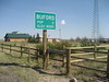
The last town in Wyoming on I-80 before reaching Utah is a town called Evanston. That was funny. After having been on the road for so long, it was a little confusing to think I hadn’t left at all.
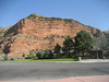
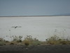 The notable aspect of Utah was all the salt. Let’s just say I don’t think we’ll be facing a salt shortage any time soon. It was just unbelievable amounts of salt mile after mile after mile. Here’s some that seems to be in production already, and here (link to large version) you can even see the Morton Salt girl from the company’s logo.
I noticed that there were stones in the salt fields making up signs, symbols and words. These went on for many many miles. Here’s a cross in the salt. I didn’t manage to capture any of the writing, but it was usually names of people, “Mary”, “Jim”, etc. with the occasional heart. I wonder who put these there. There is an Air Force base or two in the area, perhaps they’re from military folks. There are no towns around so it’s really hard to tell, and it’s a bit hard to imagine people driving cross country stopping their cars to make one of these, but I guess that’s possible as well.
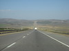 An additional memorable aspect of the trip here was the incredibly straight line of driving. Check out the map. It is not an exaggeration. There was barely a curve in the road. The only thing that breaks up this photo is the train above the highway.
Crossing from Utah into Nevada was very interesting. There is a town right on the border (which I guess then makes it two towns: Wendover and West Wendover) and there’s a mark on the pavement (not the highway, just in the town) signaling the border. I didn’t manage to capture that. Nor did I take photos of the two towns despite the very interesting difference between the two. Clearly you’d crossed into casinoland by taking that step, it was impossible to miss.
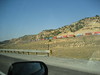
 In addition to the Casinos, the only other memorable part of Nevada was the change in scenery, finally. It took a while, but eventually there was some elevation and some trees again, which was refreshing.
The road from Nevada crosses into California right around Lake Tahoe so immediately the traffic picked up. There was also much more vegetation, and very pretty at that. The descent was unbelievably steep at times, somewhat stressful, in fact.
As proof of how much the pressure changed from the Western border of California in the Lake Tahoe region to the Eastern part of the state in the Bay area, check out the difference betwen these two pictures of the same bottle, before and after opening it at the end of the trip:


Not long after came the many-lane highways and bridges, welcoming me to my home for the next nine months.
 Other random observations throughout: I got a kick out of following the railroad at various points in the trip. There were unbelievably long stretches of trains. It’s good to see this resource still in use. There were some monuments and sculptures scattered on the highway, which were also interesting enough.
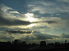
And while there wasn’t always much on the ground to entertain the traveller, the sky was really beautiful at times.
September 18th, 2006 at 12:25 am
welcome, eszter, to the bay area!
September 19th, 2006 at 11:08 am
Thanks, David, forgot that you were in the neighborhood, we’ll have to get together sometime!
September 19th, 2006 at 5:29 pm
Great post, Eszter. Though I confess I didn’t click on ALL the links. It’s cool to hear your observations on my country.
I looked at some shots of the campus too–it does look like it could be both relaxing and productivity enhancing. I hope you savor your time there!
September 20th, 2006 at 8:28 pm
This is a great and detailed post. I didn’t click on every link, but I enjoyed your views as a somewhat-outsider.
I also love dthe pictures of your new campus office space. It looks both relaxing and stimulating at the same time. Savor your time there!
(I thought I posted this comment earlier–sorry if you end up with two versions.)
September 21st, 2006 at 12:21 pm
Thanks, Steph, glad you liked it. I wish you had such an update as well!:-) Seriously, now that you’re back in grad school, I think it’s time to start blogging and Flickring.:-)